• Welcome to RCCrawler Forums.

    It looks like you're enjoying RCCrawler's Forums but haven't created an account yet. Why not take a minute to register for your own free account now? As a member you get free access to all of our forums and posts plus the ability to post your own messages, communicate directly with other members, and much more. Register now!

    Already a member? Login at the top of this page to stop seeing this message.

Crawlerado Crawling Atlas

Broomfield Community Park - ball fields/skate park

From I-25. 120th West to Lamar, North to Community park lane. Follow it around to the very end next to the Skate Park. The rocks/spillway area is on the south east side of the lot.
Lamar is the 2nd light west of Sheridan (it runs between Applebees and a bank). You can see the skate park if you look behind Century Chevrolet while you are on 120th.
It was getting a bit dark tonight when I took these, but, you can still see it OK.

North side of creek,
DSCN0187.jpg


south side of creek,
DSCN0188.jpg


Booger Bug
DSCN0189.jpg
 
Last edited:
112th & Vrain - Dry Creek Trail

Westminster area, West of Front Range Community College.

From Sheridan and 112th Ave, go east to the light at Vrain - about 1.5 blocks. Turn right on Vrain and park on the road by the school yard. The rocks are just off of 112th on the west side of Vrain. During the summer there is water in the bottom, but there is plenty of rocks to play on.

DSCN0177.jpg


DSCN0178.jpg
 
Here are a few practice areas near Broomfield. A few are not easy access, but great rocks.

Don't think it's worth a long drive, but if you are near Westminister or Broomfield area you might like it.

I'll get some pictures up from each site. Heading out to ROAR region 10 championship this weekend so give me a few days.

W 6th and hwy 287
http://maps.google.com/maps/ms?hl=e...89136636111816.0004513a73a7d657c4f22&t=h&z=16

hwy 287 and Mirimonte
http://maps.google.com/maps/ms?hl=e...89136636111816.0004513a587114bcb9cae&t=h&z=17

hwy 128 (behind flatirons mall) This one is super long run but only about as wide as a farming ditch. Looks cool for a rock race course, but parking is hard. Gotta park along side of a busy road...
http://maps.google.com/maps/ms?hl=e...89136636111816.0004513a43acbceede101&t=h&z=18
 
Westminster Westin Hotel

Right behind the Westin Hotel, there are a couple of spots.
Good for practice but not enough room for comps, sorry to say.
http://maps.google.com/?ie=UTF8&ll=39.889404,-105.064973&spn=0.001132,0.002747&t=h&z=19
This 1st link is a man made wall with a ledge. Some up and down stuff and very grippy material.

http://maps.google.com/?ie=UTF8&ll=39.890668,-105.062135&spn=0.001132,0.002747&t=h&z=19
This 2nd link is of some rock down by the creek. Low lying rock here and just enough room to get 3 or 4 people in the willows before it's crowded.

Here are some pics of both spots.

JC
8)
 
Last edited:
A New-Old spot

Some of the guys that have been around probably know this place.
http://maps.google.com/maps?f=q&hl=....996638&spn=0.007181,0.019226&z=16&iwloc=addr
I-25 and Thornton Parkway, go west to Conifer Rd and turn right. Take Conifer to Huron, turn right and go North to TR Croke Drive and turn left. Park anywhere there by Croke Drive Park. The rocks are on the South and East side of the intersection @ Conifer Rd. and Huron St.

The walk is easier than Red Rocks, but not as convenient as say, Lutz. There are some nice climbs. This gets Southeast sun exposure well into the afternoon and there isn't much shade until then, should make for some ok crawling this winter. A little water in the bottom, nothing serious-just be aware of it.
rocks001.jpg

rocks002.jpg

rocks003.jpg

rocks004.jpg

rocks005.jpg

rocks006.jpg

rocks007.jpg


LMK if you want to go!!!8)

Stan.
 
Last edited:
When the water is lowish in Horsetooth reservoir like it is now, there is a lot of fun to be had on both the North and South ends of the Dixon Canyon Dam (the Dam just West of the CSU Stadium). Park off the side of the road, walk down towards the reservoir, and have fun!
 
another spot.....

kipling and jewell in lakewood next to the tire shop med sized square edged rocks its right next to the road /part of the landscaping so thats kind of annoying but its a nice spot to stop for a min if you are driving by or live locally steep in some areas pretty fun
 
58th and York there is a pretty good spot for anyone who lives in the area, shady neighborhood though. Its about a mile south of I-25 and 58th."thumbsup"
Don't ask me why I was there.:lol:
 
Crawling spots near Canon City

These pictures are from Red Canyon Park just north of Canon City on Red Canyon Rd. http://www.coloradobirdingtrail.com/trails/rocky-mountains-site.php?trail=3&id=801 This is an ok site to give you an idea of the park. A few other places around Canon are Beaver Creek SWA, Phantom Canyon, Tunnel Drive, Temple Canyon, And Texas Creek which is a good distance west of Canon. I have a few "secret" places that no one else knows about....mostly because they are private property!!;-) This time of the year is awesome for crawling because there are no snakes:shock: out right now!!!

Here is a little map of some of the locations, Keep in mind that most all of these locations are not really Parks but do have plenty of crawling off the roadsides on public lands. Location E is private land.
http://maps.google.com/maps?f=d&sou...8.537424,-104.941406&spn=1.07202,2.460937&z=9
 
Last edited by a moderator:
S.E. Aurora by Eagle Crest H.S./South Lands Mall

Area is off of the new portion of Picadilly, between Quincy and Chenango overy by Eagle Crest H.S. The rocks are large and cemented in. You need to park in the new construction area that only has 3 houses right now and walk along Picadilly to get to this spot. There are also other rock hills like this in the area and those all have water coming down them.

link to map of area:
http://maps.google.com/maps/ms?hl=e...91,-104.736716&spn=0.002049,0.005606&t=h&z=18

IMG_1713.jpg

IMG_1712.jpg

IMG_1715.jpg

IMG_1716.jpg
 
Eldorado springs.

This is in Eldorado Springs, Right @ the base of the State Park. they have the water diverting around the damn, so this is what your left with till about may.

Then the state park, which is famous for rock climbing is chock full of mountains and rocks and stuff. $6 to drive into the park.

but if your waterproof, the creek bed is fantastic.
 
Last edited by a moderator:
Valmont park

Great spot in boulder, tons of rocks for the crawlers, far from the hippies, prarie dogs to hunt with your slash and enough space and peace to even run nitro. just take 36 west to foothills, foothills north to valmont road, go east a mile or 2 to airport rd and hang a right. big free parking lot 50 yards from a massive rock pile and in the middle of a field. check it out and hit me up if you wanna crawl.

aaron
 
Forsberg/ Iron springs park lakewood

http://maps.google.com/maps?hl=en&um=1&ie=UTF-8&q=15900+W+Alameda+Pky+Lakewood,+CO+80228&fb=1&geocode=16893008319183322783,39.684368,-105.180965&ei=3X2cSrHfFY2AswORx8STDg&sa=X&oi=manybox&resnum=1&ct=14
nice little spot, has a picnic table to sit at while crawling, great view of the off limits red rocks spot, dog park etc. quite a few fun lines. from 470 take the new alameda exit. will be on your right at the top of the hill. the spot is right by the parking lot on the west side
 
i know its probably and old spot but at I25 & round 20th ave exit (by downtown), (east side of river) south platte by REI under the bridges is a nice area of rocks, everytime we there we draw a crowd.. nice to practice
 
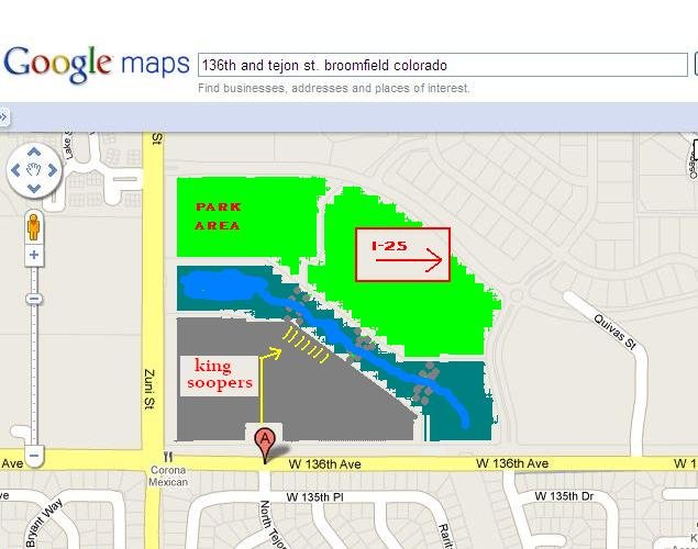
Quail Creek 136th & Tejon st.

Step ponds and drainage area on the north side of Quail Creek Shopping center/King Soopers at 136th & Tejon St. in Broomfield,,,at the light turn into the shopping center and drive straight through til you get to the large parking area on the north side of the center,,you'll see a pond in front of you and to your left,,,there are three decent sized drainage area within 300 feet. Big Rocks and little ones,, set in cement, but a nice area to crawl, there is water in the drainage area but doesnt seem to bad,,you dont have to get wet unless you want too.
 

Attachments

  • quail creek drainage.jpg
    quail creek drainage.jpg
    45.6 KB · Views: 2,234
Last edited:
Back
Top